|
|
||
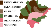 |
The material making up the mountain circle surround our Region could be dated as being from the Primary Era (between 570 and 390 million years). On these, and due to the effect of successive transformations of the orogenic activity, other materials have been deposited at the centre of the Region: Carboniferous Sediments • Tertiary Era Sediments • and the Quaternary Era gives rise to various terraces and the current hydrography of the Bierzo. HYPSOMETRY |
|
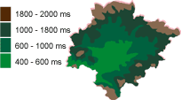 |
El Bierzo has a complex morphology. The border of the region is a mountain circle where some peaks outstand, being higher than 2,000 meters. In lower areas we encounter medium altitude lands, former floodplains, rounded tops and eroded hills. The tectonic plate corresponds to the inner Bierzo where terraces and the current hydrographic basin have been formed. HYDROGRAPHY |
|
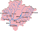 |
The river Sil is the main Bierzo axis crossing the region and gathering the water from important tributaries. On the right side: The Selmo, Burbia and Valcarce, Ancares and Cúa rivers. On the left, the Boeza, Tremor, Noceda, Valdueza and Cabrera rivers. |
© Viñedos y Bodega Arturo García S.L.
info@bodegarturo.com - Tel.: (+34) 987 553 000 - (+34) 987 553 004